
Advocacy - we are a living lab for better urban waterways
NYC needs more #piers4boats! Look around NYC, do you see boats all over the place? Boats you can get on, recreational boats or commercial ones offering tours, fishing, or dinner cruises? Are there lots of educational boats around, historic and otherwise? Are there lots of places for you to put your own boat into the water? Are there lots of watersport places where you can rent kayaks, sailboats, go waterskiing, parasailing, snorkeling and such? Do you see freight ferries moving goods around the city such as food and fish from the Hunts Point Market, e-commerce and last-mile freight? Do you see NYC connected to a regional waterborne freight network, a blue highway, called “short sea shipping” or “marine highway” that reduces local and interstate truck traffic and its pollution and wear and tear on our roads? Do you see our school system using the harbor, the defining feature of our archipelago, as a major teaching tool?

NYc bluespace
You don’t, a shocking absence in a city with 520 miles of coast, over 35 islands, and a vast, sprawling harbor, what we call the BLUEspace, the reason NYC is here in the first place.
The questions above are ways to help you imagine the potential of the harbor for recreation, tourism, transportation, culture and education. All those things exist elsewhere, most of them close to NYC. We can and should have them too!
To get all that, we need more #Piers4Boats and a shift in City policy. More maritime uses on our waterways and waterfront will make our transportation greener (with the boom in ecommerce we really need the marine highway), reduce our carbon footprint AND commute times, grow recreational uses of the largest open space in NYC (the harbor), create many new businesses and job opportunities, and enrich our educational system with the vibrancy of maritime place-based education.
#rethinkEDC
In November 2022, PortSide launched the campaign #rethinkEDC to call on NYC to rethink what the NYC Economic Development Corporation (EDC) does, how, and for whose benefit. Such a rethink will grow maritime uses in NYC since the EDC has a large maritime portfolio AND improve matters for PortSide (the EDC is our landlord) and for Red Hook (the EDC runs the large Atlantic Basin facility here with the Brooklyn Cruise Teminal, NYC Ferry dock and a their new homeport being built, Pier 11, Pier 12, and a sea of asphalt connecting it all.) The EDC is a nonprofit, a quasi-governmental organzation, NYC’s largest landlord, a group that plans NYC’s flood protection system, runs the NYC Ferry and food markets, does rezonings, and more. See our webpage rethinkedc.
PortSide’s years of searching for a home reveal the need for change
Our nonprofit was founded to change all this. However, 18 years after being founded in 2005, award-winning PortSide continues to struggle to get a place to do all this. We battle the impediments to maritime activity we were founded to change. Our plan was (and is) to create an innovative maritime center PortSide NewYork, a “living lab for better urban waterways.” That place would be an inspiration presenting a buffet of all that could be possible on a better urban waterway (an exciting array of maritime activity complemented by our educational and cultural WaterStories programs which would illuminate the history and potential of the waterways). We would have visiting vessels. Training on site for mariners to get licenses. B-to-B services to workboats, helping them and giving us revenue, and showing that public-access and working waterfront can co-exist. PortSide’s advocacy work would “talk the talk” and explain the merits of it all and how to change policy to get more of it in NYC.
Here’s a 2016 powerpoint of ours summarizing some of the impediments to maritime acitivity in NYC from when we gave a talk as part of the Deep Dives series.

OUR 2007 RENDERING IN AN RFP RESPONSE TO THE NYC EDC. FROM 2008 INTO 2011, THE NYC EDC PROMISED US THIS PARKING LOT AND THE SOUTH END OF THIS ATLANTIC BASIN, RED HOOK WAREHOUSE and 600’ of pier 11 here to program AND NEVER DELIVERED. this home for portside was a “community give-back” to red hook for a 2009 lease the edc signed with phoenix beverages. the edc got public pr credit for that give back but has yet to deliver it.
Our footprint in Atlantic Basin, Red Hook, Brooklyn is reduced to a historic ship, the MARY A. WHALEN; but, as special as she is, we need building space for long-planned programs (youth boat building shop, library and computer center, space for exhibits, movies, conferences, classrooms for use in general public education and specialized merchant mariner training to get Coast Guard licenses; better office space for us), plus outdoor program space, and the ability to host visiting vessels of all sorts, from workboats to boats the public can board. We need 12,000 square feet, a slice of the south end of the Pier 11 warehouse. More on that in our 2018 business plan.
We also need red tape reduced. PortSide is currently expected to submit “ops plans” (operations plans) to the EDC, and our dockmaster for every event on our ship with over 50 people (the notification limit was 20 people until fall of 2023). What kind of lease (a berthing permit in our case) obliges you to approve every element of your ongoing business? Not to mention that our ship is insured for many more people than that and we have never had an incident or claim in all our years of operation, and often one of the parties on the cc line does not answer in a timely fashion. The rules imposed on us also block us from any revenue-generating activity which creates financial challenges.
In June 2021, we asked people to submit comments to the Department of City Planning “Comprehensive Waterfront Plan” (CWP) asking that PortSide finally get a right-sized home with less ridiculous site-control, aka red tape. Over 200 people did, TWO THIRDS of all comments submitted to the CWP called for right-sizing PortSide. So do quotes from elected officials and other supporters in our 12/1/22 press release about our campaign #rethinkEDC for a better PortSide, a better Red Hook, a better NYC.
Our policy proposals are informed by years of experience
PortSide policy suggestions below are informed by our extensive experience delivering programs while battling NYC red tape and poor pier design. We have programmed at an astoundingly diverse array of sites (containerport, shipyard, parks, storefronts, streets, schools, historic ships beyond our own) and looked at over 20 sites while seeking a proper homeport. We brought more historic ships to Brooklyn than major parks. All this makes us very informed about what works and doesn’t in this harbor. We have provided WaterStories place-based education programs to students from elementary to graduate school from public, private and charter schools from NYC and overseas. Our impact includes including inspiring PS 676 to become Brooklyn’s first maritime elementary school. We have done award-winning resiliency planning and hurricane Sandy recovery work and inspired a FEMA flood signage program. See our awards and select accomplishments here.
Solutions for NYC
To answer yes to all the questions at the top of this page, NYC needs a waterfront planned, built, managed and permitted by people dedicated to the waterfront AND THE WATERWAYS, by informed specialists. Non-maritime people, under the strong influence of real estate developers, have had a huge influence shaping NYC’s waterfront the past few decades. The price has been the displacement of the working waterfront, waterfront parks that treat the harbor as little more than a view and asset for adjacent condos, and a boom in luxury condos along the waterfront leading to gentrification. In NYC, low-income New Yorkers often have more access to waterfront in their neighborhood while it is “un-improved” before a new park arrives, since the parks often are linked with real estate developments that force out the original residents.
NYC’s waterfront management needs a higher level of competence, fewer silos, less bureaucracies to chase down, less red tape and needs to favor water-dependent uses and be more accommodating to maritime uses. PortSide proposes the following changes:
Finally provide a right-sized home for PortSide! All our plans have depended on building space, and our footprint has been reduced to historic ship MARY A. WHALEN which has just a few tiny interior spaces. We need 12,000 square feet at the southern end of the Pier 11 warehouse in Atlantic Basin, Red Hook where we are now. That warehouse is largely empty. The NYC EDC promised us building space here from 2008 into 2011 and never deliveed it. Here is info about our third plan for the space done in 2018.
Switch the planning focus to “waterway use” not just “public access” to the waterfront. The former is use, the latter is just getting to the edge to look at or be near water. Many a dull esplanade, with no way for boats to come and go, has been created as a result of the focus on “public access.”
Change policy so that maritime uses are mandated or incentivized (opportunity zone for maritime?) the way that public access is mandated when there is a rezoning change.
Design the edge to be more boat friendly. Many park piers built in the past 20 years were built for pedestrians not boats. Several piers that were built for boats, were badly designed (see one case history here), a reason we call for 5 below.
Have maritime users, not landscape architects, lead waterfront park design, and design piers for boats not just pedestrians. #Piers4boats
Reduce the red tape that makes it hard to find and use operating spaces for all types of boats (recreational, commercial, industrial, historic/educational, transient/visiting, and maritime special events). On top of bad pier design, obstructive management makes our waterways hard or impossible to use. Get in touch with us for details, the ways this is done are many; it’s death by a thousand cuts.
Bundle NYC waterfront planning and permitting into a single department of the waterfront.
Mandate greater transparency and responsiveness on the part of entities planning and running the waterfront for the City.
Grow a robust, financially sustainable ferry network reaching all parts of NYC. We admire much about the new NYC Ferry system, but it requires massive subsidies.
Grow ways to move freight within the city by water, with a strong focus on last mile logistics. For decades, UPS and FedEx depots have been within yards of the water, and the surge in e-commerce is leading to a boom in construction of waterside e-commerce warehouses that threatens to bury neighborhoods in truck traffic. They should get their freight by water. NYC’s wholesale market for produce and fish Hunts Point is on the water; ship those perishables around NYC by water to local distribution hubs. Our crash course in last mile marine highway for non maritime people is here.
Be more willing to mix waterways uses and users at one site. Example: allow freight boats carrying fish and produce from the Hunts Point Market to dock in parks, and add a fishmarket/greenmarket around the terminal in the parks, an idea we have pushed since 2006! NYC currently has a hard divide between working waterfront and public-access. Other parts of the USA and places in Europe do more blending, and co-habitation. PortSide’s proposed maritime center would create synergies between the different user groups and be an inspiring example for NYC!
Look for inspiration in USA waterfronts with a lot of maritime activity. Some are close! See New England and Baltimore and our blogpost comparing NYC and Portland, Maine.
Ensure that resiliency plans don’t reduce options for maritime use, where ever possible. Ports are apertures and many resiliency plans are walls. We would like to see NYC assess the feasibility of surge-powered barriers (or any kind of temporary wall) rather than the current focus on permanent barriers, burms, and elevating the whole site.
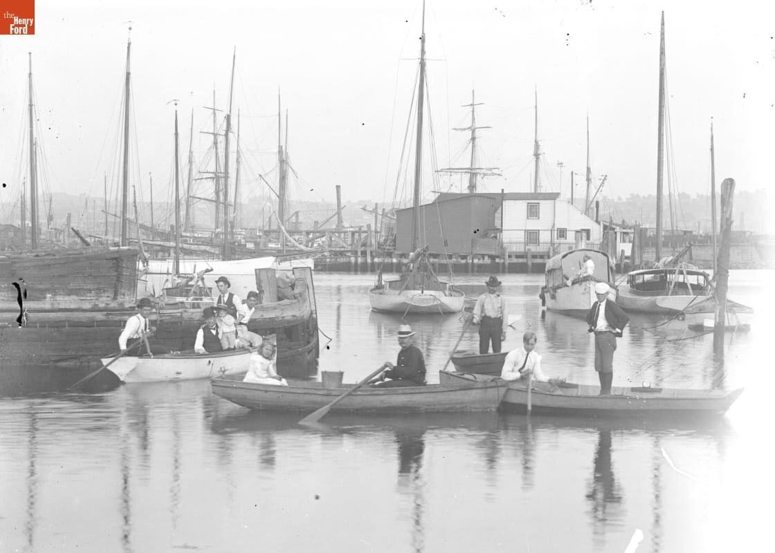
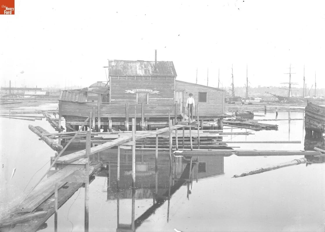
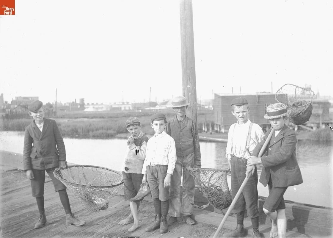
Increase opportunities for low-income New Yorkers to get on boats. Back in the day, before the mid-20th century, many NYC working-class, waterfront neighborhoods had docks, piers, boats to rent, floating pools, maybe a beach. (See 3 photos below for examples from Red Hook, Brooklyn.) NYC lost all that; and as waterfront amenities have returned, they tend to be installed in wealthier, whiter areas where parks predominate already. Plus, waterfront parks tend to make areas wealthier and whiter since they are often built as part of a neighborhood rezoning (shifting zoning from manufacturing) or as part of constructing waterside, luxury, residential developments. For example, during the entire 12 years of the Bloomberg administration, only 3 spots for historic ships were added on public property in NYC, all of them on Pier 25 in Tribeca, Manhattan. Only one of the three has been consistently used by a historic ship due to pier design and management challenges! Free kayaking programs are the one boating sector to have grown notably in the past 20 years, a credit to their relentless advocacy. If NYC allowed for access to the water at street-ends, this would considerably increase access for small boats.
13. To make this all happen, change the political structure to give maritime more political force? There is no representative for the waterways. Could there be a Councilmember and Community Board representing NYC waterways? Waterways and maritime users are underrepresented in NYC’s political system; no one political entity has more than a sliver of our vast waterfront. However, large industrial maritime businesses serve the city and/or region but are represented by a NYC Councilmember for a small area, not someone with the power to speak for the whole archipelago. Other maritime users (non-profit and for-profit) have boats that want to move around this harbor, and they have to negotiate with sites in many community boards and council districts while lacking the strong advocate of a rep for the whole waterways. Time to change the political structure to make NYC a real maritime city again? PortSide believes that NYC needs to find a way to mandate or incentivize maritime uses of private property. The Department of City Planning found a way to mandate “public access to the waterfront” when property is re-zoned; that has led to a lot of pedestrian esplanades but not access to and use of the waterways itself.
PortSide’s public programs illuminate some of these possibilities and issues. We also do advocacy work in more conventional ways: We submit testimony (see below); we work directly with government agencies and the staff of elected officials; we answer questions posed by harbor users, the general public and the media. We also use our social media to promote a greater understanding of the harbor and how to achieve “better urban waterways.” Our Waterways Info page has additional info.
Select presentations & testimony
Help incubate small, community-focused waterfront enterprises. We co-authored a white paper called Waterfront Community Stewardship Zones Proposal with Roger Meyer, who has since left NYC for more maritime-friendly waters.
Portify as we fortify. Don't let Sandy drown a good idea. Our president Carolina Salguero argued in a 2016 presentation at AIANY that we cannot let post-Sandy resiliency plans drown the good ideas of Vision 2020, NYC’s last comprehensive waterfront plan. To activate our waterways, we need apertures, not solid seawalls.
Policy recommendations sent to the de Blasio transition team after his 1st election "Unlocking the potential of NYC’s waterfront, A progressive road map for the Sixth Borough." These were publicly released in May, 2016.
Recommendations to create piers that are more boat-friendly
VISION 2020 - NYC'S NEW COMPREHENSIVE WATERFRONT PLAN & 2021 update
11/12/10 PortSide input to Vision 2020 During 2010, NYC conducted a year-long process to create a comprehensive waterfront plan called Vision 2020. This was the second such plan in the City's history, and it updated one from the 1980s. It recognized that prior revitalization had focused on the land, the waterfront edge, and not the waterways. Vision 2020 plan touted the potential benefits of what it called the “Blue Highway” and “Sixth Borough." However, Vision 2020 led to few real changes. This was partly because Sandy drowned its good ideas: that storm hit soon after the plan was released, making the waterways seem more like danger than opportunity and shifting the focus to resiliency. However, the resistancy of bureuacracies to change also played a big role in Vision 2020 falling flat.
The plan’s name reflects the commitment to update the plan every ten years, so this plan is in effect until 2020. In 2020, though hindered by the pandemic, the Department of City Planning began work on the next 10-year plan, and ran late due to the pandemic. DEADLINE FOR COMMENTS WAS JUNE 2021. The final plan was released in the last days of the de Blasio adminstration.
The Department of City Planning accepted feedback on their CWP draft goals and strategies through the plan's website and during virtual public meetings.
Vision 2020 has an action component for the NYC EDC known as WAVES.
Related Department of City Planning Waterfront Revitalization Program
portside Testimony to the City Council
12/7/21 Testimony to Parks Committee calling for repair of Red Hook Rec Center boiler damaged by hurricane Ida and installation of Valentino Park toilet approved in 2018.
5/23/20 Call for #NYCBudgetJustice and protecting the budget for for DYCD (Youth and Community Development) being slashed more than other agencies, testimony submitted to New York City Council Finance Committee in response to the proposed City budget that reflects the high costs of COVID19 to NYC.
4/17/19 Establishing an office of the waterfront, NYC Ferry operations, Testimony submitted to New York City Council Committee on Governmental Operations jointly with the Committee on Economic Development and the Committee on Transportation. The video is in a link near top of this page. Our ED Carolina Salguero speaks from 02:08:30 to 02:13:25.
12/14/17 Investing in the City’s Maritime Industry Workforce, Testimony submitted to The New York City Council Committee on Waterfronts
10/18/17 The Economic Impact of NYC Ferry and the New Ferry Transport Routes, Testimony submitted to The New York City Council Committee on Waterfronts
12/5/16 Improving Boater Safety in the City's Waterways, Testimony submitted to The New York City Council Committee on Waterfronts
5/19/15 Subcommittee on Landmarks, Public Siting and Maritime Uses, topic LU 0224-2015, proposed maritime lease between the New York City Department of Small Business Services (SBS) and the New York City Economic Development Corporation (EDC) for South Brooklyn Marine Terminal (SBMT) and related blogpost
3/16/12 "Transforming NYC's Waterfront - one year update on Waterfront Action Agenda (WAVES). PortSide led an effort to have this hearing have a major focus on the needs of historic vessels in NYC. Here is PortSide testimony, and see our blogpost for more testimony about this hearing which generated impassioned advocacy for historic ships.
12/14/06 South Brooklyn Working Waterfront oversight hearing by the Land Use Subcommittee Landmarks, Public Siting, Maritime Uses, and the Committee on Waterfronts
10/31/06 Rules of the Road, sharing the waterway City Council Waterfronts Committee
2/13/06 General waterfront issues City Council Waterfronts Committee
6/15/05 Regulatory Obstacles to Waterfront Development (the DEC) City Council Waterfronts Committee, includes a discussion of DEC policy's effect on Red Hook, Brooklyn.
1/12/05 Waterfront Employment City Council Waterfronts Committee
Select portside testimony to other entities
10/8/15 Testimony to EDC regarding proposed Citywide ferry DEIS
3/20/15 Testimony regarding the Port Authority Cross Harbor TEIS
portside role in Red Hook Waterfront issues
Bowne Storehouse In 2018 and 2019, we advocated for maritime uses of the site rather than converting the manufacturing zoning and building high-rise luxury condos, and preservation of the historic Bowne Storehouse. The building was demolished, after arson, in a process that included illegal demolition, rule breaking and rule bending. No plans have been approved to build on site.
Lidgerwood building, new UPS site In 2019, we advocated for preservation of the historic facade facing Valentino Park, moving freight in by water, using renewable energy on site (including tidal power), local hiring, and a providing a home for PortSide on site. Plans for the site are ongoing as is our involvement. We believe they should bring in freight by water.
We have been active regarding issues relating to the Thor Equities property (former sugar refinery) at 280 Richards. These related to local flooding and spread of dust from dirt mounds resulting from their work and advocating for maritime uses of their future plans. The site is now becoming an e-commerce warehouse for Amazon. We believe they should bring in freight by water.
We provide a historical summary of EDC planning initiatives relating to western Red Hook port sites: the Red Hook Container Terminal, the Brooklyn Cruise Terminal and Atlantic Basin. This history shows the EDC pattern of doing lots of plans with little action. They say they often use RFPs (requests for proposals) to gauge market interest, but the RFPs come with so many mandates and prohibitions that they often generate little response. Given this pattern, and the EDC tendency to use the RFP process as a way to harvest ideas, many entities are now reluctant to execute these demanding processes when there is a high chance they don’t win or that their ideas will be stolen. Full disclosure, in seeking a home in Atlantic Basin, Red Hook PortSide did THREE plans for the EDC: a 2006 RFEI, a 2007 RFP after which the EDC promised a home we did not receive, and a 2018 business plan. We still lack the building space, pier space, and outdoor space ashore to fulfill our vision.
Though not a maritime planning topic, PortSide has been very involved in the Red Hook discussion around getting a public toilet in our local waterfront park Valentino Park. Our blog posts here and here illuminates some of the issues. The inter-agency logjams and slow pace of this story (the fracas kicked off in 2014 and, as of December 2021, there is still no toilet) reflects the same kind of bureaucratic impediments outlined above.