Red Hook flood assessment info: our watershed, sewers, buried creeks, prior shoreline & more
/Amended 11/12/14 to include the following link and background about Eymund Diegel:
For related info, see our blogpost that includes Jim McMahon's Sandy flood map of Red Hook and info on how to assess your flood risk in future storms."
More info about Eymund Diegel:
- Eymund Diegel LinkedIn profile
- Eymund Diegel website
- Eymund Diegel profile in New York Times
- Eymund Diegel TEDx Talk
Original post:
To further support flood prevention planning in Red Hook, we offer the following information.
The data and points of view in the following bullet points are courtesy of Eymund Diegel:

- General imagery of the Sandy Flood impacts available here
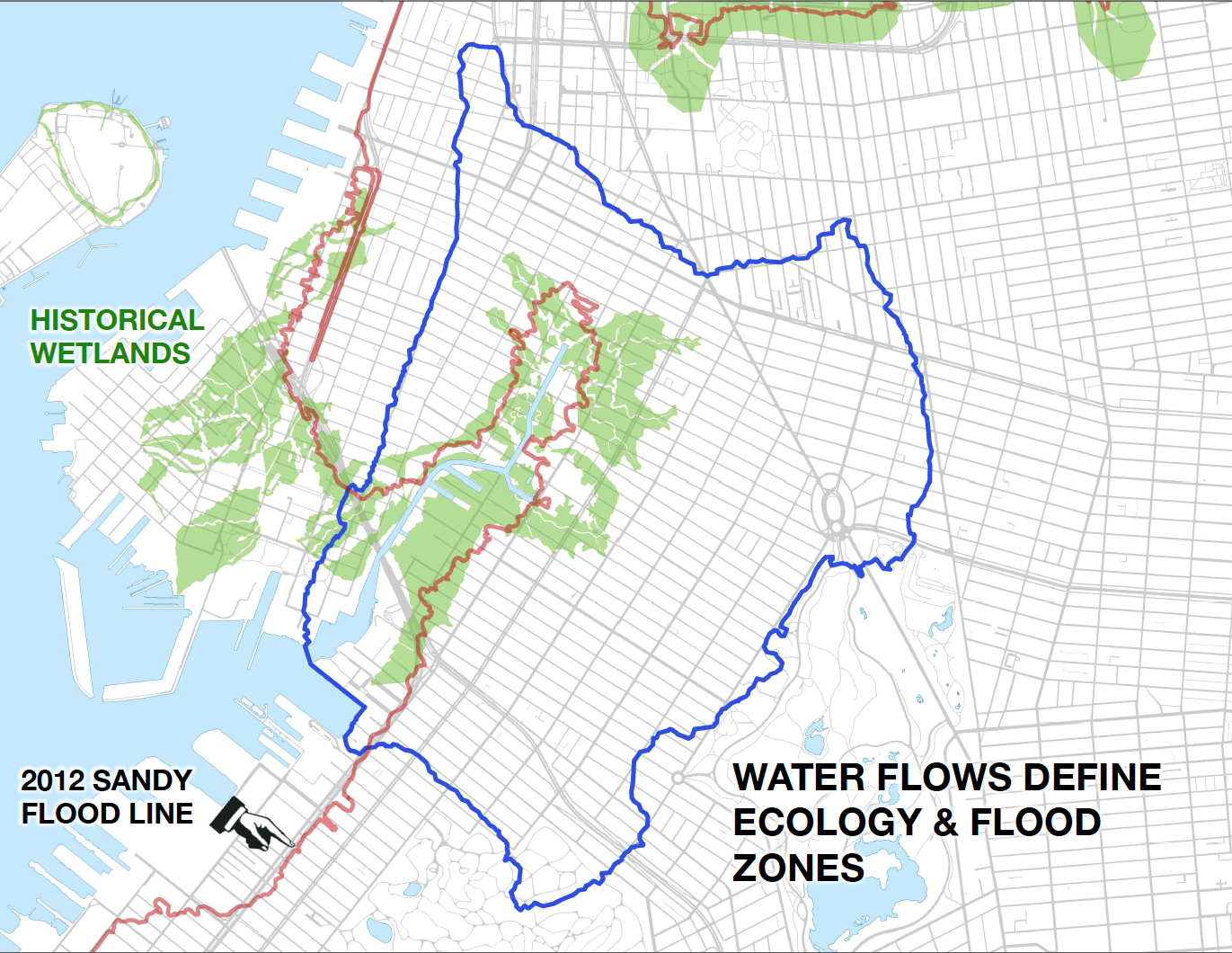
- Base map data showing where flood waters are likely to come from next time Blue lines show general direction of drainage flows, and in reverse, the likely path of rising flood waters. Green shows the original tidal marshes. Sandy essentially flooded anyone who built on the former tidal marshes.
- 1844 Coastal Survey showing original sand and mud banks off Red Hook whose alteration from harbor dredging is affecting how storm surges impact Red Hook
- The reconstruction of the historic bay bottom, in particular it's now damaged and altered offshore banks, should be studied to see how reconstructing some of these protective features may help reduce Red Hook flood damage the next time.
- I am attaching some ideas from the excellent work being done by SCAPE landscape architects, (slide show above) exploring how we remove soil from some areas (eg Red Hook Park) to recreate a better flood holding basin, and use those soils to create surge breakers further offshore. All expensive and controversial, but we need to start this dialogue as we are only going to get more flood events, and the next one will be worse than Sandy. We got off lucky because we didn't have heavy rains.
- I did a 2013 Sandy Flood saline impacted tree survey for the Parks Department
- The most impacted trees (London Planes and Dawn Redwoods) were typically on "topographic sinks" where salt water sat for longer, affecting soil quality and damaging non salt tolerant trees. These "sinks" generally correspond with the location of the historic mill ponds that were landfilled and subsided.
- The planning recommendation I made to the City is that street grading needs to be improved to allow flood waters to recede more rapidly. This recommendation will contradict some of the Brooklyn Waterfront Greenways Green Infrastructure work (eg on Columbia Street) where storm water is being diverted to pond swales and holding tanks to reduce combined sewer overflows. Both (flood management and green infrastructure sewer overflow reduction are good goals and should be supported. One compromise strategy may be sluice gates, like those used by the original millers of Red Hook to better manage tide waters.


Brooklyn Greenway Stormwater Study for West Street in Greenpoint, Brooklyn includes ideas to consider