EDC and Red Hook's Atlantic Basin 2024
/
EDC in Atlantic Basin 2024
Last update 9/17/24
Detailed background info about the 2023 community efforts to improve EDC policy in Atlantic Basin and the Brooklyn Cruise Terminal (BCT) is in this blogpost
Content about the “Brooklyn Marine Terminal (BMT) process” aka “the landswap between the City and the Port Authority has been moved to a new blogpost so that this one will focus on the efforts to improve Atlantic Basin and Brooklyn Cruise Terminal before the BMT land swap news was announced on 5/14. For now, we are splitting the traffic management topic and economic development topic into two sections, rather than presenting all chronologically.
5/24/24 Congressmember Dan Goldman, Council Member Aviles, and Senator Gounardes jointly released an Op-Ed about the land swap here. Note that is says that the Task Force that they are heading will have “ultimate approval authority.” We have sent questions to Goldman’s office about how this will work. More as we know it.
Economic Development - before the land swap news
Soon after the March 2024 community victory of the unanimous City Council vote that passed the cruise ship bill (mandating shorepower use and traffic mitigation plans), the EDC reached out and restarted the community planning process led by Councilmember Alexa Aviles where community members had met weekly on Zoom with the EDC during summer 2023. We’re picking up where we left off; starting the discussion of “economic development” (meaning how to make Atlantic Basin and BCT contribute to the economic development of Red Hook).
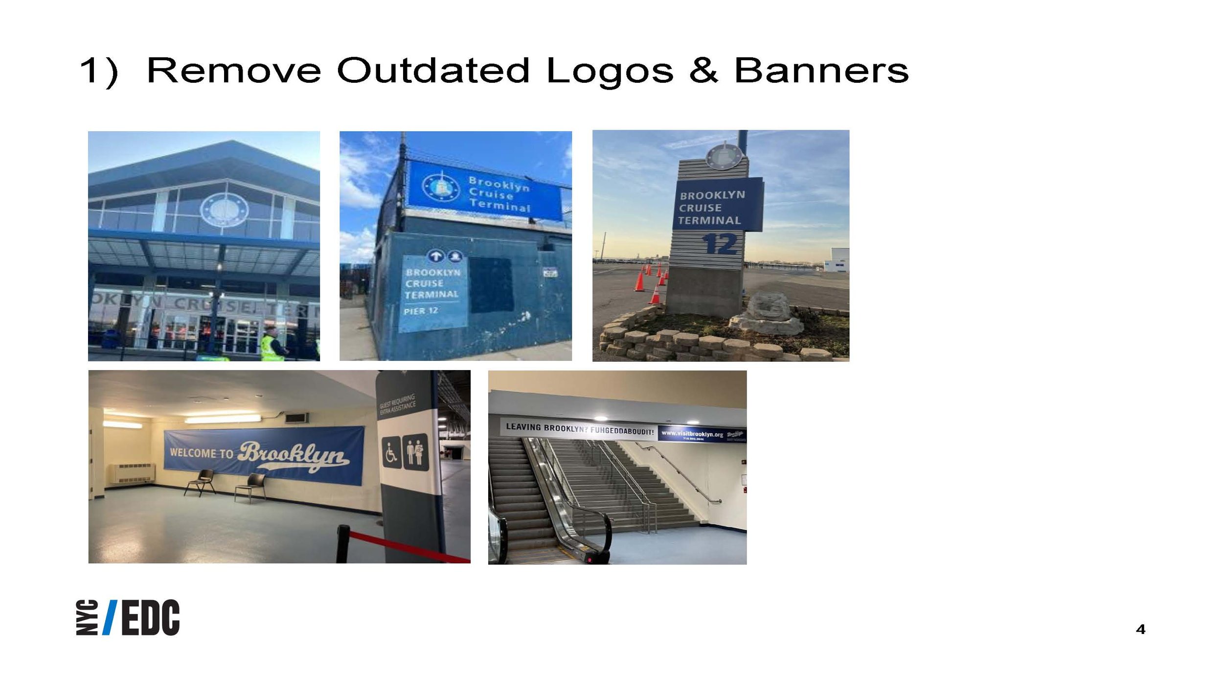
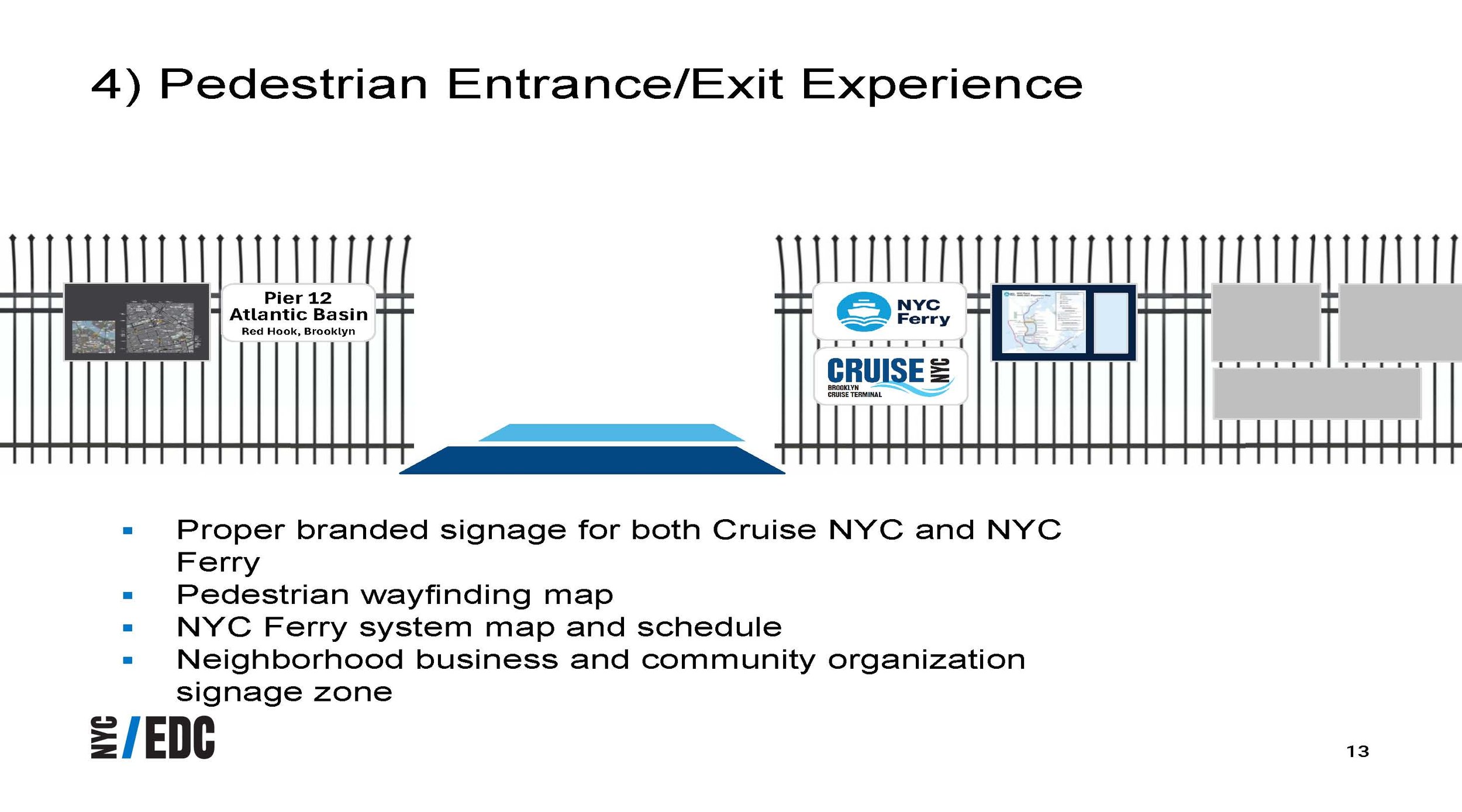
Late March, the EDC sent an email offering to add and upgrade signage so that BCT would promote Red Hook. PortSide has been calling for this for years, and the new Red Hook Business Alliance also pushed hard for this last year. Such improvements would start to fulfill promises the EDC made to Red Hook in 2005 as they planned the cruise terminal and said it would benefit Red Hook. From 2008 into 2011, the EDC also promised PortSide a home here with sufficient space. We still seek that!
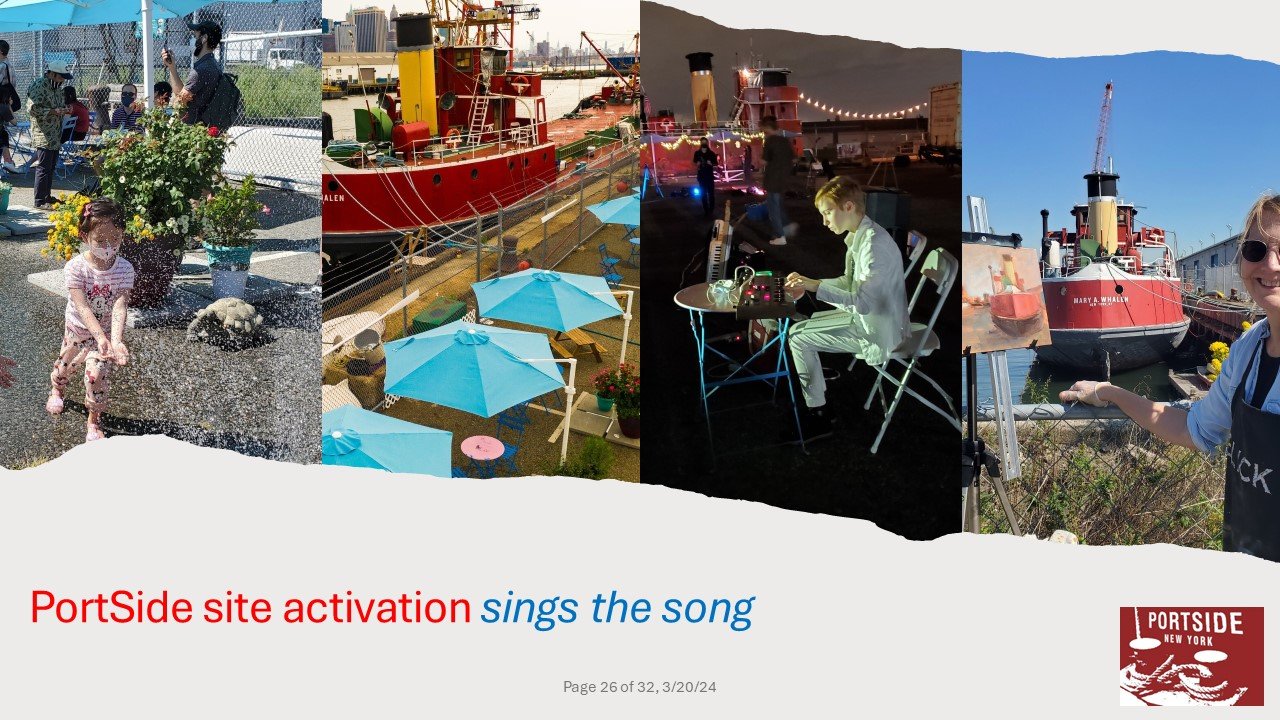
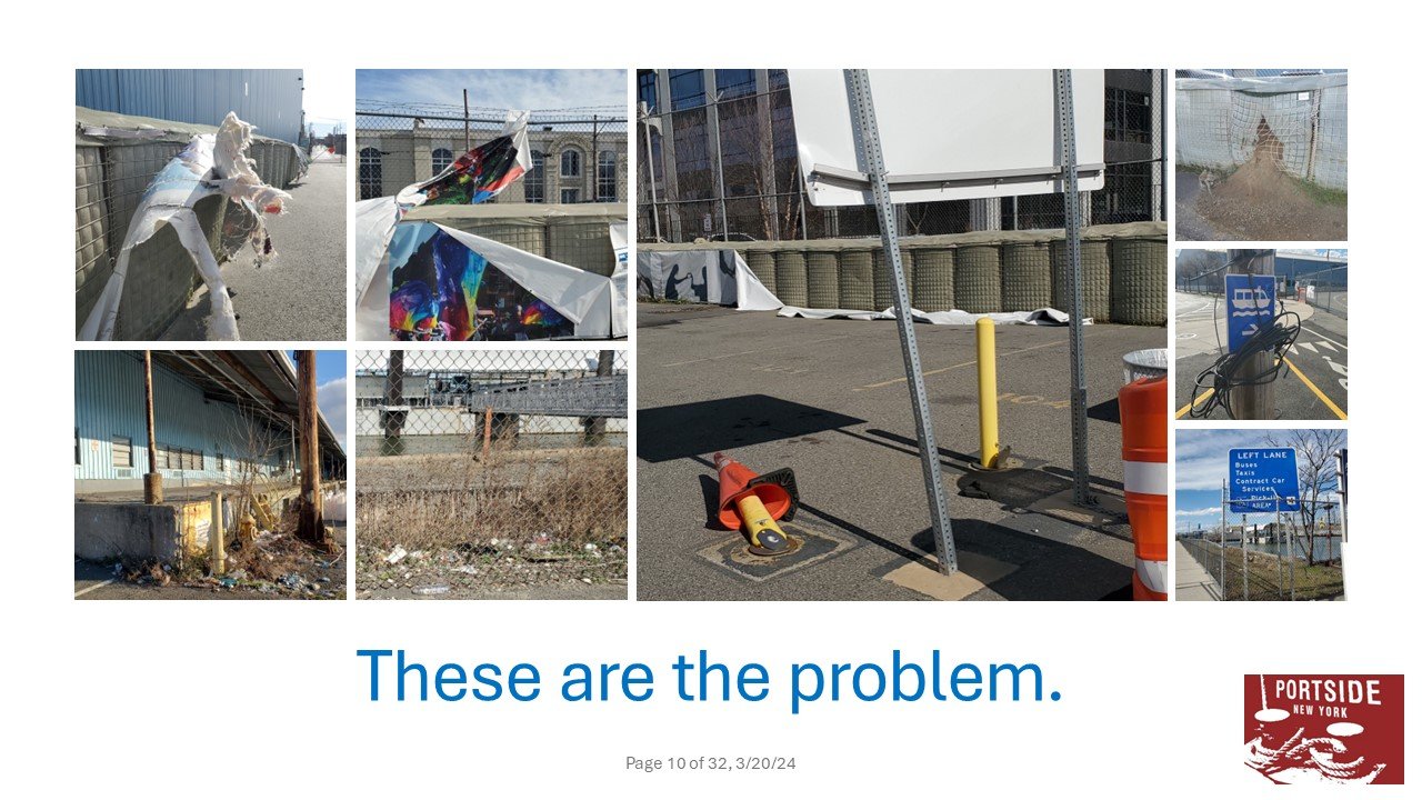
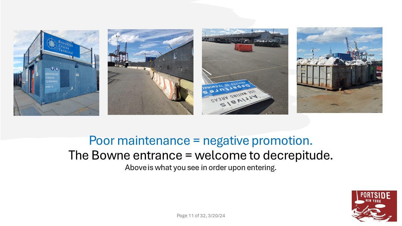
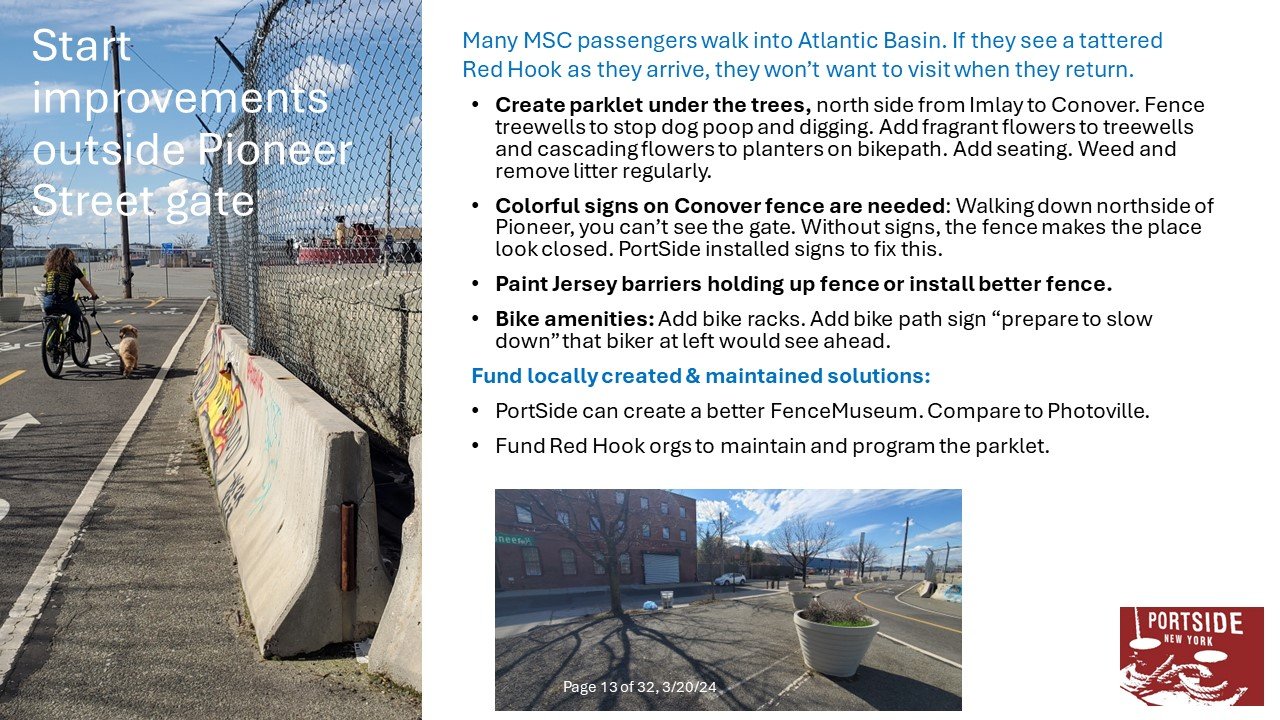
3/21/24 PortSide PowerPoint in response, proposing other improvements including a right-sized space for us. Note the “PortSide Campus” on pages 25-32, excerpted for your convenience here. The EDC seems to have absorbed the part of our presentation that stressed the negative image conveyed by broken things and litter, and hired a work crew to clean and weed M-F. The place is looking better! Next goal, more space for PortSide! People love PortSide! Read the 47 support letters we got in that many hours when we asked for support for a grant application in February here.
Some excerpts of both presentations below. The EDC approach focused heavily on sign design and condition; the PortSide approach was more holistic and about place-making and “site-activation” (programming). We invoked Walt Whitman’s poem “I Hear America Singing,” and said the efforts here need to sing the song of Atlantic Basin and Red Hook. PortSide sings that song!
March 19, there was a walk-though led by the EDC from the Pioneer Street pedestrian gate, through BCT and back.
May 2, the EDC emailed back to us and the working group “We can't commit to a nature center but our team is mindful of maintaining this space with the wildlife in mind.” For years, we’ve been asking to create a nature center in the water and in the green space south of the Mary Whalen. That’s in the proposed “PortSide Campus” here.
May 8, there is a follow-up Zoom with the EDC expanding the cc line to include staff from all the local electeds.
The EDC is providing $35,000 to the Red Hook Art Project (RHAP) to create three murals, one on the ground entering Atlantic Basin and following the pedestrian route to the Brooklyn Cruise Terminal, and two more, we think, inside the terminal. This is in line with our suggestions to the EDC that they fund local entities to execute many of the upgrades to the site that would promote Red Hook, beautify and activate the site. The kick-off meeting for the ground mural was on 6/5/24. Follow the social media of RHAP for udates, or email them here.
BCT Traffic Update
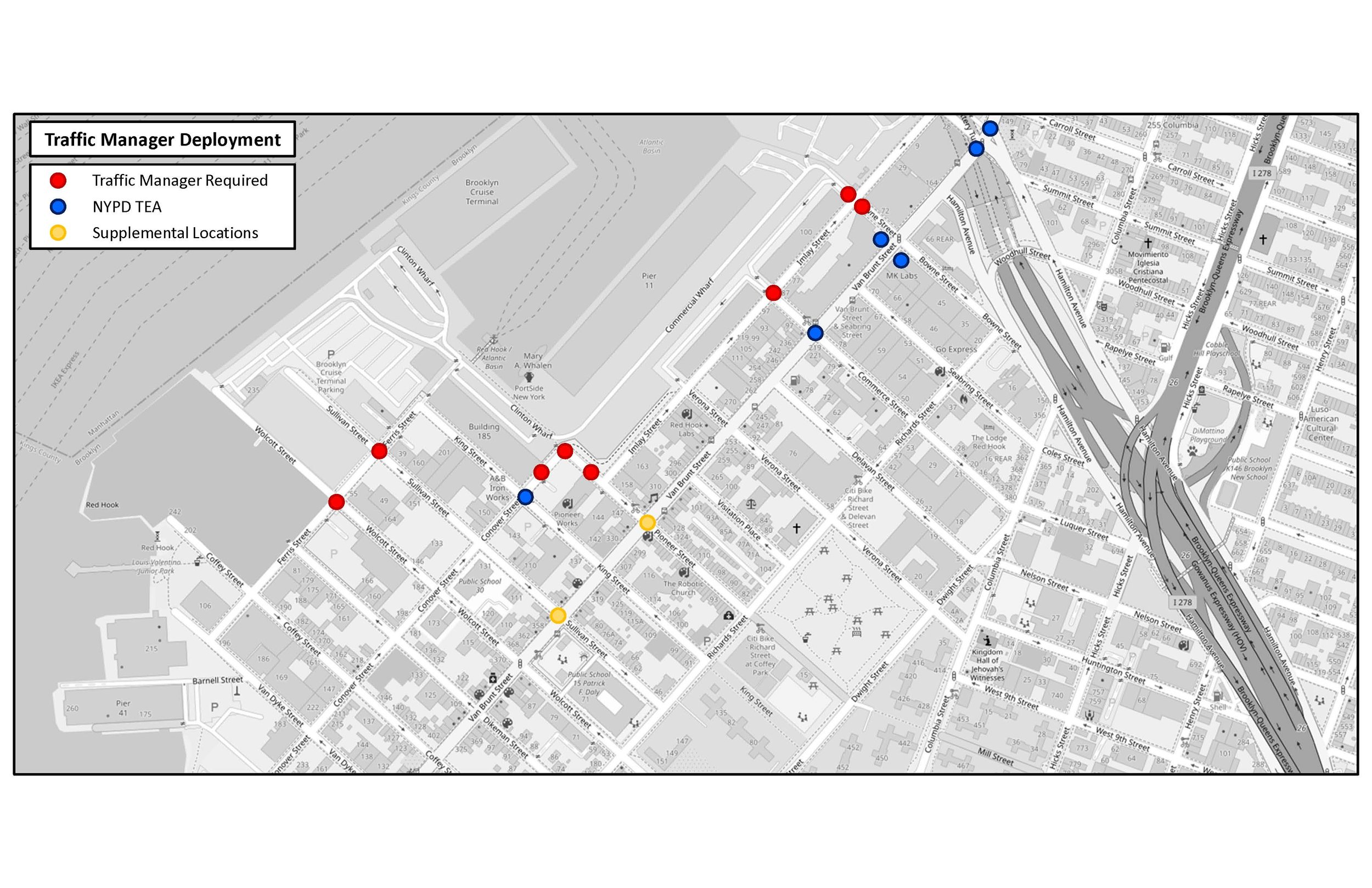
4/26/24 email from Tara Das, EDC (came with map above)
“Good afternoon,
Thank you for your continued partnership and feedback on the traffic management plan that was developed with EDC and WSP with support from DOT last summer. As a reminder, that plan established the following parameters, which continue to be in place:
Between 8 and 13 traffic agents staffed for each MSC cruise call at the locations outlined in the attached map
Basin traffic flow on ship call days widened from one-lane to two-lanes inbound to increase capacity within the terminal and minimize traffic queuing within the neighborhood. These increases are currently achieved through coning. Changes to the pavement markings are currently being designed for installation which will allow for the increased capacity of inbound Atlantic Basin traffic at all times (and not just ship call days).
Software updates were made with GPS providers (Google, Waze, Apple) to reflect the correct entrance to the facility via the Bowne Street gate.
Recommendations were made to NYCDOT to change Ferris St between King Street and Sullivan Street to one-way southbound. Following these discussions, NYCDOT enacted that change and has installed multiple “Do Not Enter” signs to prohibit northbound traffic on this block.
Ped/Bike warning signs were proposed at the Bowne St gate to alert exiting traffic regarding the Brooklyn Waterfront Greenway. These signs are currently in the process of being procured to then subsequently be installed.
We have continued to coordinate with WSP on the next phase of traffic planning. In fall 2023, WSP gathered extra traffic data from about twenty intersections in the neighborhood to study peak traffic at four scenarios:
Sunday with and without a ship call, and
Monday with and without a ship call.
This new data was used to create a detailed traffic analysis using Synchro Traffic Simulation software. Synchro is widely used in the industry to model traffic at intersections and small road networks. For the model, we input details about each roadway, such as whether it's controlled by stops or traffic signals with set timings. The traffic volumes used represent the busiest hours we have observed. Using this information, Synchro calculates various outcomes like Level of Service (LOS), which measures average vehicle delay, average queue lengths at entry points, and volume to capacity (v/c) ratios, indicating how traffic volume compares to the intersection's capacity. This network helps us understand delays at specific intersections and compare traffic delays on ship call days versus non-ship call days.
WSP is using this system to evaluate alternate traffic routing, including the suggestions that Matías Kalwill has raised in our meetings (thank you again for sharing these with us!). Since these options are being considered for shorter-term implementation, that is being factored into the evaluation.
Below is a status of all suggestions under consideration:
Reversing the direction of traffic Summit St and Imlay St (between Summit St and Bowne St) - being studied in Synchro
Rerouting inbound traffic along SB Van Brunt St to Commerce St and Imlay St. (This was tried occasionally last summer in the field as an experiment, but will now be analyzed). - being studied in Synchro
Additional parking restrictions along Van Brunt St for cruise days to increase capacity – being studied in Synchro
Rerouting traffic through Red hook Container Terminal: initial study determined that this would entail significant interference with the movement of freight in this area
Rerouting traffic for BCT onto Hamilton Av West Bound (in the East Bound direction): initial study determined that reversal of traffic would encounter geometric issues and may further disrupt the flow of traffic
Regarding shuttles: we are collecting survey data for the upcoming season to inform potential shuttle routing. After a thorough review to pinpoint optimal origin pick-up points, the data will undergo an extensive multi-week routing refinement to determine shuttle routes that are more likely to attract ridership and diminish the dependency on private vehicles. The intricacies involved in this process mean that implementation is projected to commence no earlier than mid-summer. We appreciate your understanding as we aim to ensure the best possible outcome for shuttle implementation and adoption.
In the upcoming weeks of the high season, we will continue to take a very targeted approach to traffic management, which involves having traffic enforcement agents (a combination of PD officers and contracted agents). EDC has brought on a new Traffic Enforcement Agent company, Workforce7, who is an MWBE company. The new team has undergone robust onboarding that included shadowing the current traffic managers and sharing best practices to be ready to anticipate neighborhood traffic issues and sensitivities for the duration of the season. Their first on-site job will be this Sunday.
We thank you all for your continued partnership and feedback. Please reach out with any questions.”